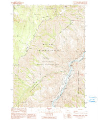
1990 Map of Temperance Creek
USGS Topo · Published 1990About this map
Snake River whitewater and steep canyon walls define this section of the Oregon-Idaho border at the edge of the Wallowa National Forest. Navigational hazards along the river include the Little Bar Rapids, Hominy Creek Rapids, and Slaughter Gulch Rapids, indicating the difficult passage through this corridor. On the Oregon side, human activity is marked by isolated outposts such as Wisner Place, Brockman Ranch, and the Kneeland Place (Site), highlighting the sparse, ranch-oriented settlement patterns of the late twentieth century. High above the river, the Summit Ridge provides a spine for the Summit Ridge National Recreation Trail, passing through Ninemile Saddle. Remnants of earlier extractive efforts appear near the riverbank as Mine Tunnels, while the complex topography is further detailed by named features like Suicide Point and Mormon Flat.
Find a feature on this map
46 named features on this map. Tap any name to fly to it.
Don’t see what you’re looking for? This feature index may not catch every label — zoom into the map to look around manually.
Map Details
Editions of this 1990 Temperance Creek Map
This is the sole edition of this map. No revisions or reprints were ever made.
Other maps of this area

1922 · He Devil
USGS Topo · 1:48,000

1938 · Riggins
USGS Topo · 1:96,000

1945 · Riggins
USGS Topo · 1:125,000

1954 · Kernan Point
USGS Topo · 1:62,500

1955 · Grangeville
USGS Topo · 1:250,000

1957 · He Devil
USGS Topo · 1:62,500

1959 · Grangeville
USGS Topo · 1:250,000

1963 · Kirkwood Creek
USGS Topo · 1:24,000

1963 · Grave Point
USGS Topo · 1:24,000
1964 · Kessler Creek
USGS Topo · 1:24,000