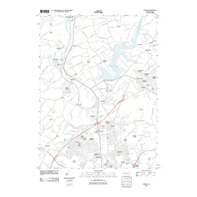
2010 Map of Temple
USGS Topo · Published 2010About this map
The Schuylkill River and its industrial and residential corridors dominate this landscape, flowing through a region of established settlements like Leesport and Shoemakersville. The waterway is punctuated by historic infrastructure including Rieser Mill Dam and Felix Dam, reflecting a history of river management alongside the Schuylkill Valley RR. Significant water features such as Ontelaunee Lake and the Bernhart Reservoir indicate the region's role in local water supply and recreation, while the sprawling residential developments of Muhlenberg Park and Laureldale show the suburban expansion around the city of Reading. Numerous historical sites are preserved across the area, from the Blandon Post Office to numerous burial grounds like Gethsemane Cemetery and Good Shepherd Cemetery. This map captures the intersection of traditional river-based industries and mid-century modern infrastructure, including the Reading Municipal Airport and Grube Airport.
Find a feature on this map
146 named features on this map. Tap any name to fly to it.
Don’t see what you’re looking for? This feature index may not catch every label — zoom into the map to look around manually.
Map Details
Editions of this 2010 Temple Map
This is the sole edition of this map. No revisions or reprints were ever made.
Other maps of this area

1889 · Pottsville
USGS Topo · 1:62,500

1891 · Pottsville
USGS Topo · 1:62,500

1894 · Reading
USGS Topo · 1:62,500

1902 · Wernersville
USGS Topo · 1:62,500

1909 · Hamburg
USGS Topo · 1:62,500

1911 · Hamburg
USGS Topo · 1:62,500

1913 · Reading
USGS Topo · 1:62,500

1915 · Reading
USGS Topo · 1:62,500

1943 · Wernersville
USGS Topo · 1:62,500

1944 · Reading
USGS Topo · 1:62,500
Featured Places
- Muhlenberg Park, Muhlenberg Township
- Laureldale, PA
- Leesport, PA
- Shoemakersville, PA
- Ontelaunee Township, PA