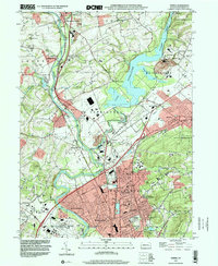
1999 Map of Temple
USGS Topo · Published 2001About this map
The Schuylkill River and the expansive Lake Ontelaunee define the geography of this Berks County landscape at the close of the 1990s. The water bodies are flanked by a dense network of industrial and residential developments, particularly in the southern sector where the boroughs of Temple, Laureldale, and Hyde Park converge. This area demonstrates a high degree of infrastructure integration, including the Reading Municipal Airport General Carl A Spaatz Field and several major substations, reflecting the suburban expansion of the Reading metropolitan area.
Find a feature on this map
59 named features on this map. Tap any name to fly to it.
Don’t see what you’re looking for? This feature index may not catch every label — zoom into the map to look around manually.
Map Details
Editions of this 1999 Temple Map
This is the sole edition of this map. No revisions or reprints were ever made.
Other maps of this area

1889 · Pottsville
USGS Topo · 1:62,500

1891 · Pottsville
USGS Topo · 1:62,500

1894 · Reading
USGS Topo · 1:62,500

1902 · Wernersville
USGS Topo · 1:62,500

1909 · Hamburg
USGS Topo · 1:62,500

1911 · Hamburg
USGS Topo · 1:62,500

1913 · Reading
USGS Topo · 1:62,500

1915 · Reading
USGS Topo · 1:62,500

1943 · Wernersville
USGS Topo · 1:62,500

1944 · Reading
USGS Topo · 1:62,500
Featured Places
- Muhlenberg Park, Muhlenberg Township
- Laureldale, PA
- Leesport, PA
- Shoemakersville, PA
- Ontelaunee Township, PA