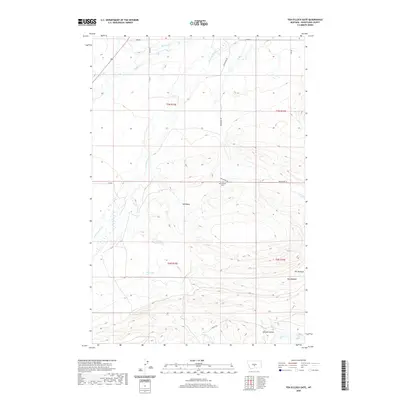
2020 Map of Ten O'Clock Gate
USGS Topo · Published 2020About this map
Red Basin dominates the central landscape of this Wheatland County survey, where the drainages of the American Fork and Spring Creek converge. The terrain is defined by its water sources, most notably at Big Spring, which feeds into the local creek system amidst the undulating topography of Altman Coulee. This high-plains environment is punctuated by long-established ranching and transit landmarks such as Ten O'Clock Gate, situated at a key junction of Red Bridge Road.
Find a feature on this map
18 named features on this map. Tap any name to fly to it.
Don’t see what you’re looking for? This feature index may not catch every label — zoom into the map to look around manually.
Map Details
Editions of this 2020 Ten O'Clock Gate Map
This is the sole edition of this map. No revisions or reprints were ever made.
Other maps of this area

1889 · Big Snowy Mountain
USGS Topo · 1:250,000

1893 · Big Snowy Mountain
USGS Topo · 1:250,000

1954 · Roundup
USGS Topo · 1:250,000

1958 · Roundup
USGS Topo · 1:250,000

1985 · Jim Creek
USGS Topo · 1:24,000
1985 · Gougley Creek
USGS Topo · 1:24,000
1985 · Melville NW
USGS Topo · 1:24,000
1986 · Ten O'Clock Gate
USGS Topo · 1:24,000
1986 · Devils Pocket
USGS Topo · 1:24,000
1986 · Harlowton SW
USGS Topo · 1:24,000