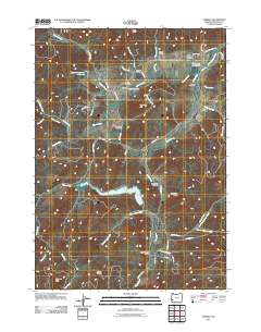
2011 Map of Tenmile
USGS Topo · Published 2011About this map
Tenmile Valley and the Upper Olalla Valley define the southern Oregon landscape of this Douglas County survey. The settlement of Tenmile serves as a primary hub, centered around the Tenmile Post Office and the nearby Tenmile Cemetery. The map documents a rural network of homestead-era names and family burial sites, including the McCulloch Cemetery and McGuire Cemetery. Water management is a significant feature of the local geography, evidenced by the Edward Wageman Reservoir, Berry Creek Reservoir, and the industrial Cleveland Log Ponds near the northern boundary. The terrain transitions from these valley floors toward prominent landmarks like Mount Shep and Chimney Rock in the southwest. A complex system of creek drainages, such as Olalla Creek and Berry Creek, feeds these reservoirs, illustrating the vital relationship between the local topography and water resources in the early 21st century.
Find a feature on this map
62 named features on this map. Tap any name to fly to it.
Don’t see what you’re looking for? This feature index may not catch every label — zoom into the map to look around manually.
Map Details
Editions of this 2011 Tenmile Map
This is the sole edition of this map. No revisions or reprints were ever made.
Other maps of this area

1897 · Roseburg
USGS Topo · 1:125,000

1900 · Roseburg
USGS Topo · 1:125,000
1904 · Riddle
USGS Topo · 1:125,000
1928 · Sitkum
USGS Topo · 1:125,000
1946 · Dutchman Butte
USGS Topo · 1:62,500
1948 · Dutchman Butte
USGS Topo · 1:62,500
1954 · Canyonville
USGS Topo · 1:62,500
1955 · Camas Valley
USGS Topo · 1:62,500
1955 · Roseburg
USGS Topo · 1:62,500

1955 · Medford
USGS Topo · 1:250,000