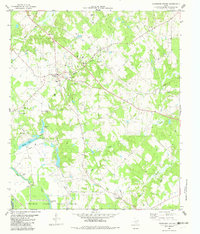
1982 Map of Tennessee Colony
USGS Topo · Published 1982About this map
Tennessee Colony and Harmony serve as the primary focal points of this East Texas survey, which reveals a landscape deeply influenced by its water resources and emerging energy extraction. The terrain is defined by the winding paths of Beaver Creek and Keechie Creek, feeding into a complex system of local water bodies including Spring Lake, Prairie Lake, and Cedar Lake. This area of Anderson County and Freestone County shows a distinct transition between agricultural use and industrial development, marked by numerous Oil Wells and a Gas Well scattered among traditional landmarks. Cultural and social foundations are represented by the Providence Ch and the Jimmison Quarter Cem. To the south, the extensive grounds of the Coffield State Prison Farm occupy a significant portion of the landscape, bordered by the Slough and the marshy edges of Snag Lake.
Find a feature on this map
25 named features on this map. Tap any name to fly to it.
Don’t see what you’re looking for? This feature index may not catch every label — zoom into the map to look around manually.
Map Details
Editions of this 1982 Tennessee Colony Map
This is the sole edition of this map. No revisions or reprints were ever made.
Other maps of this area

1949 · Palestine
USGS Topo · 1:62,500

1949 · Tennessee Colony
USGS Topo · 1:62,500

1950 · Palestine
USGS Topo · 1:62,500

1950 · Tennessee Colony
USGS Topo · 1:62,500

1951 · Elkhart
USGS Topo · 1:62,500

1953 · Palestine
USGS Topo · 1:250,000

1957 · Palestine
USGS Topo · 1:250,000

1964 · Long Lake
USGS Topo · 1:24,000
1964 · Butler
USGS Topo · 1:24,000

1981 · Palestine
USGS Topo · 1:100,000