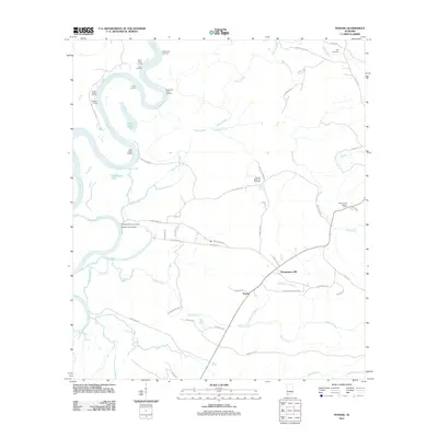
2011 Map of Tensaw
USGS Topo · Published 2011About this map
Montgomery Hill and Tensaw anchor the eastern landscape of this river-bound region, where the winding Alabama River defines the western edge. This 2011 survey highlights a deep-seated river economy marked by numerous landings, including Silver Landing, Singleton Landing, and McDonald Lower Landing, indicating the continued importance of these access points in Baldwin County. The interior is crisscrossed by family-named roads and drainage systems like Holley Creek and Slaughter Branch. Significant local landmarks provide historical depth, from the Tensaw Memorial Cemetery to the Fort Mimms Lookout Tower. The northern reaches include the South Carlton Oil Field, reflecting the industrial side of the local landscape alongside natural features like Silver Lake and Southfield Lake.
Find a feature on this map
53 named features on this map. Tap any name to fly to it.
Don’t see what you’re looking for? This feature index may not catch every label — zoom into the map to look around manually.
Map Details
Editions of this 2011 Tensaw Map
This is the sole edition of this map. No revisions or reprints were ever made.
Other maps of this area

1942 · Perdido
USGS Topo · 1:62,500

1943 · Choctaw Bluff
USGS Topo · 1:62,500

1943 · Tensaw
USGS Topo · 1:62,500

1944 · Tensaw
USGS Topo · 1:62,500

1944 · Perdido
USGS Topo · 1:62,500

1946 · Choctaw Bluff
USGS Topo · 1:62,500

1953 · Andalusia
USGS Topo · 1:250,000

1957 · Andalusia
USGS Topo · 1:250,000

1972 · Chrysler
USGS Topo · 1:24,000
1983 · Vaughn
USGS Topo · 1:24,000