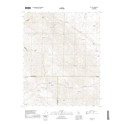
2018 Map of Tent Hills
USGS Topo · Published 2018About this map
Tent Hills and the surrounding high country of the Diablo Range define this landscape where the borders of Monterey, Kings, San Luis Obispo, and Kern counties converge. The terrain is deeply incised by numerous canyons, including Poison Oak Canyon, Catskin Canyon, and Stoker Canyon, which channel seasonal runoff into the Avenal Creek and Cottonwood Creek systems. A legacy of early transport is visible in the historic Cholame Valley Wagon Rd and the Little Avenal Creek Trl, which navigated these ridges before modern infrastructure. Higher elevations such as Johnson Peak and Three Peaks offer vantage points over the San Joaquin Valley to the east, while geographic markers like Blue Point and Cottonwood Pass provide specific orientation points for those studying the regional transition from the coastal mountains to the Central Valley.
Find a feature on this map
37 named features on this map. Tap any name to fly to it.
Don’t see what you’re looking for? This feature index may not catch every label — zoom into the map to look around manually.
Map Details
Editions of this 2018 Tent Hills Map
This is the sole edition of this map. No revisions or reprints were ever made.
Other maps of this area

1914 · Cholame
USGS Topo · 1:125,000

1915 · Cholame
USGS Topo · 1:125,000

1917 · Cholame
USGS Topo · 1:125,000

1930 · Kettleman Plain
USGS Topo · 1:31,680

1933 · Kettleman Plain
USGS Topo · 1:31,680

1934 · The Dark Hole
USGS Topo · 1:31,680

1934 · Reef Ridge
USGS Topo · 1:31,680
1937 · Reef Ridge
USGS Topo · 1:31,680
1937 · The Dark Hole
USGS Topo · 1:31,680

1942 · Tent Hills
USGS Topo · 1:24,000