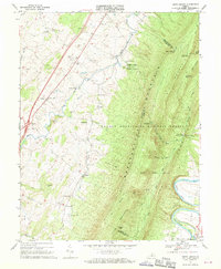
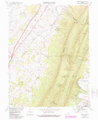
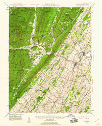
1967 Map of Tenth Legion
USGS Topo · Published 1970About this map
Massanutten Mountain dominates the eastern half of this landscape, its steep ridges and hollows like Lokey Hollow and Koontz Hollow carved by runs that feed the South Fork Shenandoah River. The valley floor to the west is a mosaic of small farming settlements and crossroads, including Tenth Legion and Mauzy, where family life centered around churches such as Bethlehem Ch and Concord Ch. The survey captures the mid-century infrastructure of the Shenandoah Valley, featuring the N & W Ry corridor and a notable Covered Bridge crossing Smith Creek. Beneath the surface of Turkey Ridge, the presence of Endless Caverns points to the region's subterranean geology, while the George Washington National Forest preserves the timbered heights above the settled valley floor.
Find a feature on this map
51 named features on this map. Tap any name to fly to it.
Don’t see what you’re looking for? This feature index may not catch every label — zoom into the map to look around manually.
Map Details
Editions of this 1967 Tenth Legion Map
2 editions found
Other maps of this area

1892 · Woodstock
USGS Topo · 1:125,000

1892 · Harrisonburg
USGS Topo · 1:125,000

1937 · Elkton
USGS Topo · 1:62,500

1941 · Harrisonburg
USGS Topo · 1:62,500

1942 · Mt Jackson
USGS Topo · 1:62,500

1943 · Harrisonburg
USGS Topo · 1:62,500

1946 · Mt Jackson
USGS Topo · 1:62,500

1947 · Mt Jackson
USGS Topo · 1:62,500
1947 · Broadway
USGS Topo · 1:62,500

1949 · Charlottesville
USGS Topo · 1:250,000