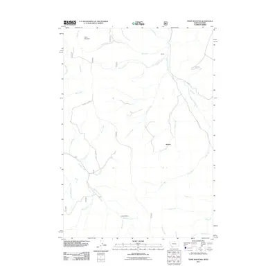
2011 Map of Tepee Mountain
USGS Topo · Published 2011About this map
Hildreth sits at the center of this high-elevation landscape, where the waters of Medicine Lodge Creek and Hildreth Creek converge. The topography is defined by the sharp transition from the Long Canyon floor to the heights of Tepee Mountain, reflecting a classic Rocky Mountain drainage pattern. To the west, the Meadow Divide serves as a natural barrier, separating the headwaters of numerous small tributaries including Poison Creek, Bog Creek, and Wheetip Creek.
Find a feature on this map
26 named features on this map. Tap any name to fly to it.
Don’t see what you’re looking for? This feature index may not catch every label — zoom into the map to look around manually.
Map Details
Editions of this 2011 Tepee Mountain Map
This is the sole edition of this map. No revisions or reprints were ever made.
Other maps of this area

1955 · Dubois
USGS Topo · 1:250,000

1956 · Morrison Lake
USGS Topo · 1:62,500

1958 · Dubois
USGS Topo · 1:250,000

1965 · Deadman Pass
USGS Topo · 1:24,000

1965 · Graphite Mountain
USGS Topo · 1:24,000

1965 · Deer Canyon
USGS Topo · 1:24,000
1965 · Medicine Lodge Peak
USGS Topo · 1:24,000

1965 · Island Butte
USGS Topo · 1:24,000

1980 · Leadore
USGS Topo · 1:100,000
1987 · Morrison Lake
USGS Topo · 1:24,000