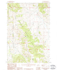
1987 Map of Tepee Mountain
USGS Topo · Published 1987About this map
Tepee Mountain stands at the center of this high-elevation terrain where the Continental Divide winds along the border between Montana and Idaho. The landscape is split between the Beaverhead National Forest and Salmon National Forest, with the state line and county boundaries for Lemhi and Beaverhead following the high ridges. This 1980s data highlights a wilderness economy defined by water and mineral exploration, evidenced by isolated markers like a Prospect and a Shaft located in the vicinity of Morrison Creek.
Find a feature on this map
30 named features on this map. Tap any name to fly to it.
Don’t see what you’re looking for? This feature index may not catch every label — zoom into the map to look around manually.
Map Details
Editions of this 1987 Tepee Mountain Map
This is the sole edition of this map. No revisions or reprints were ever made.
Other maps of this area

1955 · Dubois
USGS Topo · 1:250,000

1956 · Morrison Lake
USGS Topo · 1:62,500

1958 · Dubois
USGS Topo · 1:250,000

1965 · Deadman Pass
USGS Topo · 1:24,000

1965 · Graphite Mountain
USGS Topo · 1:24,000

1965 · Deer Canyon
USGS Topo · 1:24,000
1965 · Medicine Lodge Peak
USGS Topo · 1:24,000

1965 · Island Butte
USGS Topo · 1:24,000

1980 · Leadore
USGS Topo · 1:100,000
1987 · Morrison Lake
USGS Topo · 1:24,000