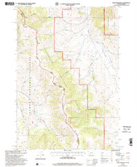
1997 Map of Tepee Mountain
USGS Topo · Published 2002About this map
The Continental Divide National Scenic Trail winds through high-altitude terrain along the border of Montana and Idaho, marking a significant hydrologic and political boundary. This late-twentieth-century survey of the Tepee Mountain area highlights the convergence of the Beaverhead National Forest and Salmon National Forest. The landscape is defined by its drainage systems, including the north-flowing Medicine Lodge Creek and several smaller tributaries like Hildreth Creek and Meadow Creek. Evidence of resource exploration is visible in the northeastern corner, where a Mine Shaft and several Adits appear near the Lodge Creek drainage. These features, along with names like Horsethief Creek and Long Canyon, point to the region's history of prospecting and ranching in the high backcountry.
Find a feature on this map
34 named features on this map. Tap any name to fly to it.
Don’t see what you’re looking for? This feature index may not catch every label — zoom into the map to look around manually.
Map Details
Editions of this 1997 Tepee Mountain Map
This is the sole edition of this map. No revisions or reprints were ever made.
Other maps of this area

1955 · Dubois
USGS Topo · 1:250,000

1956 · Morrison Lake
USGS Topo · 1:62,500

1958 · Dubois
USGS Topo · 1:250,000

1965 · Deadman Pass
USGS Topo · 1:24,000

1965 · Graphite Mountain
USGS Topo · 1:24,000

1965 · Deer Canyon
USGS Topo · 1:24,000
1965 · Medicine Lodge Peak
USGS Topo · 1:24,000

1965 · Island Butte
USGS Topo · 1:24,000

1980 · Leadore
USGS Topo · 1:100,000
1987 · Morrison Lake
USGS Topo · 1:24,000