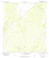
1978 Map of Tequesquite Creek NE
USGS Topo · Published 1978About this map
Tequesquite Creek and its neighboring watercourses define the ranching landscape of Kinney County in the late 1970s. This survey records a period when the Southern Pacific railroad served as the primary transit corridor across the northern portion of the quadrangle, passing through a terrain punctuated by water-scarcity solutions such as Macie Windmill and Coyote Windmill. The modest settlement at Peters stands as a focal point in a region otherwise dedicated to resource extraction and light industry, evidenced by several Gravel Pits and a modern Pipeline. Land use patterns here are further revealed by a remote Landing Strip, suggesting the vast distances managed by local landowners. The map captures the hydrological network of the arid brush country, where intermittent flows like Las Moras Creek and Cow Creek dictated the placement of early improvements.
Find a feature on this map
16 named features on this map. Tap any name to fly to it.
Don’t see what you’re looking for? This feature index may not catch every label — zoom into the map to look around manually.
Map Details
Editions of this 1978 Tequesquite Creek NE Map
This is the sole edition of this map. No revisions or reprints were ever made.
Other maps of this area

1896 · Brackett
USGS Topo · 1:125,000

1897 · Brackett
USGS Topo · 1:125,000

1941 · Standart
USGS Topo · 1:62,500

1941 · Tequesquite Creek
USGS Topo · 1:62,500

1943 · Standart
USGS Topo · 1:62,500

1944 · Tequesquite Creek
USGS Topo · 1:62,500

1944 · Spofford
USGS Topo · 1:62,500

1944 · Brackettville
USGS Topo · 1:62,500

1958 · Del Rio
USGS Topo · 1:250,000

1964 · Del Rio
USGS Topo · 1:250,000