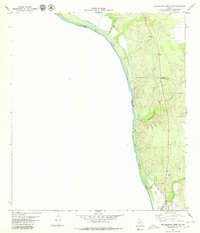
1979 Map of Tequesquite Creek SW
USGS Topo · Published 1979About this map
The Rio Grande defines the international boundary between Texas and Mexico in this 1970s survey, following a course established by treaty. The landscape is characterized by its hydraulic engineering and intermittent drainage systems, notably the Maverick County Canal which parallels the river and is indicated as being Elevated in certain sections. The inland terrain is marked by dry creek beds such as Tequesquite Creek, Las Moras Creek, and Cow Creek, which drain toward the river through the varied topography of the Kinney and Maverick county border.
Find a feature on this map
15 named features on this map. Tap any name to fly to it.
Don’t see what you’re looking for? This feature index may not catch every label — zoom into the map to look around manually.
Map Details
Editions of this 1979 Tequesquite Creek SW Map
This is the sole edition of this map. No revisions or reprints were ever made.
Other maps of this area

1940 · Quemado
USGS Topo · 1:62,500

1941 · Tequesquite Creek
USGS Topo · 1:62,500

1944 · Sycamore Ranch
USGS Topo · 1:62,500

1944 · Tequesquite Creek
USGS Topo · 1:62,500

1958 · Eagle Pass
USGS Topo · 1:250,000

1958 · Del Rio
USGS Topo · 1:250,000

1964 · Del Rio
USGS Topo · 1:250,000

1965 · Eagle Pass
USGS Topo · 1:250,000
1978 · Tequesquite Creek NE
USGS Topo · 1:24,000
1978 · Tequesquite Spring
USGS Topo · 1:24,000