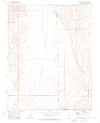
1973 Map of Terry Benches
USGS Topo · Published 1976About this map
Terry Benches dominates the center of this 1973 survey, marking a stark landscape where the borders of Nevada, Utah, and Arizona converge. The map documents a remote tri-state corner defined by intricate drainage systems and elevated plateaus rather than permanent settlements. To the east, Beaver Dam Wash carves through the terrain, while the Tule Springs Hills rise to the west, separated by the wide expanse of the benches.
Find a feature on this map
13 named features on this map. Tap any name to fly to it.
Don’t see what you’re looking for? This feature index may not catch every label — zoom into the map to look around manually.
Map Details
Editions of this 1973 Terry Benches Map
2 editions found
Other maps of this area

1885 · St. George
USGS Topo · 1:250,000

1885 · Pioche
USGS Topo · 1:250,000

1886 · Saint Thomas
USGS Topo · 1:250,000

1886 · Mt. Trumbull
USGS Topo · 1:250,000

1886 · Pioche
USGS Topo · 1:250,000

1891 · St. George
USGS Topo · 1:250,000

1892 · Mt. Trumbull
USGS Topo · 1:250,000

1893 · Saint Thomas
USGS Topo · 1:250,000

1953 · Cedar City
USGS Topo · 1:250,000

1953 · Grand Canyon
USGS Topo · 1:250,000