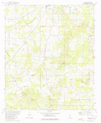
1980 Map of Terry NW
USGS Topo · Published 1980About this map
Tallahalla Creek and Snake Creek carve through the landscape of rural Hinds County, where small agricultural settlements like Fairchilds Crossroads and Dry Grove anchored the community in the late twentieth century. This survey documents a quiet rural economy defined by local timber and farming, visible in the numerous sandpits and scattered rural churches such as Bethany Ch and Palestine Ch. The northern portion of the quadrangle shows signs of institutional development, featuring the County Penal Farm and the County Voc Tech Sch alongside industrial infrastructure like the Radio Tower (WJTV). Genealogists will find significant value in the documentation of family-named landmarks and resting places, including Salmon Cem and Bedwell Cem, which provide a record of the area's established residency during this era. The terrain is marked by notable elevations such as Elda Hill, while the rail corridor of the Illinois line passes through the northern reaches near Fourteenmile Creek.
Find a feature on this map
36 named features on this map. Tap any name to fly to it.
Don’t see what you’re looking for? This feature index may not catch every label — zoom into the map to look around manually.
Map Details
Editions of this 1980 Terry NW Map
This is the sole edition of this map. No revisions or reprints were ever made.
Other maps of this area

1903 · Jackson
USGS Topo · 1:125,000

1934 · Raymond
USGS Topo · 1:48,000

1937 · Raymond
USGS Topo · 1:62,500

1937 · Terry
USGS Topo · 1:48,000

1938 · Edwards
USGS Topo · 1:62,500

1942 · Raymond
USGS Topo · 1:62,500

1943 · Terry
USGS Topo · 1:62,500

1955 · Jackson
USGS Topo · 1:250,000

1961 · Jackson
USGS Topo · 1:250,000

1962 · Jackson
USGS Topo · 1:250,000