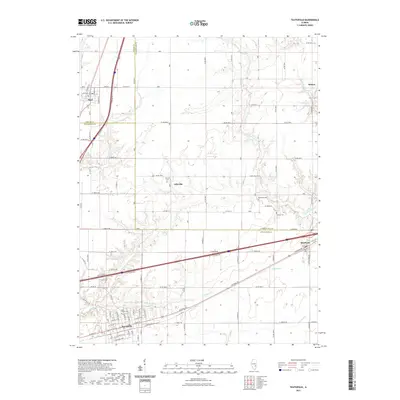
2021 Map of Teutopolis
USGS Topo · Published 2021About this map
Teutopolis anchors the southern portion of this landscape, its grid of streets such as N Plum St and N Green St revealing the organized growth of this Effingham County community. The area is defined by a series of south-flowing waterways, including Salt Cr, First Salt Cr, and Little Salt Cr, which carve through the agricultural plains. To the north and east, smaller settlements like Sigel, Lillyville, and Montrose are connected by a network of county roads and historic thoroughfares like National Rd. Genealogists will find several burial grounds mapped across the countryside, including Saint Francis Cem near the town center, and the more isolated Lillyville Cem, Needham Cem, and Faunce Cem. The map illustrates the persistent rural character of the Illinois prairie, where small hamlets like Roslyn maintain their identity along the tributary waters of Spring Point Cr.
Find a feature on this map
65 named features on this map. Tap any name to fly to it.
Don’t see what you’re looking for? This feature index may not catch every label — zoom into the map to look around manually.
Map Details
Editions of this 2021 Teutopolis Map
This is the sole edition of this map. No revisions or reprints were ever made.
Other maps of this area

1934 · Mattoon
USGS Topo · 1:62,500

1937 · Mattoon
USGS Topo · 1:62,500

1947 · Stewardson
USGS Topo · 1:62,500

1949 · Stewardson
USGS Topo · 1:62,500

1950 · Effingham
USGS Topo · 1:62,500

1951 · Effingham
USGS Topo · 1:62,500

1953 · Teutopolis
USGS Topo · 1:62,500

1958 · Decatur
USGS Topo · 1:250,000

1961 · Decatur
USGS Topo · 1:250,000
1981 · Stewardson East
USGS Topo · 1:24,000