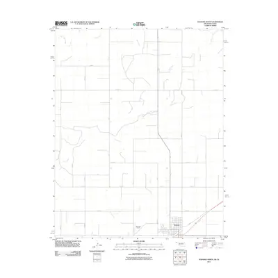
2011 Map of Texhoma North
USGS Topo · Published 2011About this map
Texhoma anchors the southern edge of this Oklahoma panhandle landscape, where the town grid transitions into a vast agricultural survey of section roads. The terrain is defined by the winding course of the Beaver River, which cuts across the central and northern reaches of the quadrangle, joined by the intermittent drainage of Sand Creek. This 2011 survey captures the area’s infrastructure, including the Municipal Airport situated just west of the main settlement and an extensive network of county routes like Co Hwy 51 and Co Hwy 53. The layout of the land reflects the traditional township and range system, with numbered routes such as Mile 11 and Mile 13 forming a rigid geometric pattern across the river valley, illustrating the deep intersection of modern aviation and traditional high-plains ranching and farming.
Find a feature on this map
28 named features on this map. Tap any name to fly to it.
Don’t see what you’re looking for? This feature index may not catch every label — zoom into the map to look around manually.
Map Details
Editions of this 2011 Texhoma North Map
This is the sole edition of this map. No revisions or reprints were ever made.
Other maps of this area

1954 · Perryton
USGS Topo · 1:250,000

1958 · Perryton
USGS Topo · 1:250,000

1965 · Stevens
USGS Topo · 1:24,000

1973 · Texhoma NE
USGS Topo · 1:24,000

1973 · Texhoma North
USGS Topo · 1:24,000

1973 · Goodwell NW
USGS Topo · 1:24,000
1973 · Texhoma SW
USGS Topo · 1:24,000
1973 · Texhoma NW
USGS Topo · 1:24,000

1973 · Goodwell
USGS Topo · 1:24,000

1974 · Sunray 1 NW
USGS Topo · 1:24,000