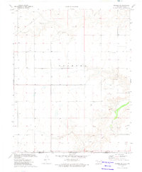
1973 Map of Texhoma SW
USGS Topo · Published 1975About this map
Beaver River and its tributary, Sand Creek, dominate the southeastern portion of this landscape along the state line where Oklahoma meets Texas. In the early 1970s, this area of the High Plains served as a hub for resource extraction and telecommunications. The map reveals a high concentration of Oil Wells and numerous Caliche Pits, indicating the importance of local road-building materials and energy production to the regional economy. Near the established settlement of Texhoma, the presence of a Radio Tower suggests the town's role as a communications node for the surrounding rural sections. The terrain is marked by a precise grid of sections and property lines, including the boundary between Texas County and Sherman County, illustrating the systematic land division characteristic of the Panhandle during this era.
Find a feature on this map
10 named features on this map. Tap any name to fly to it.
Don’t see what you’re looking for? This feature index may not catch every label — zoom into the map to look around manually.
Map Details
Editions of this 1973 Texhoma SW Map
This is the sole edition of this map. No revisions or reprints were ever made.
Other maps of this area

1954 · Perryton
USGS Topo · 1:250,000

1954 · Dalhart
USGS Topo · 1:250,000

1958 · Perryton
USGS Topo · 1:250,000

1958 · Dalhart
USGS Topo · 1:250,000

1962 · Dalhart
USGS Topo · 1:250,000

1964 · Stratford NE
USGS Topo · 1:24,000

1965 · Stevens
USGS Topo · 1:24,000

1971 · Griggs NE
USGS Topo · 1:24,000

1971 · Griggs
USGS Topo · 1:24,000

1973 · Texhoma NE
USGS Topo · 1:24,000