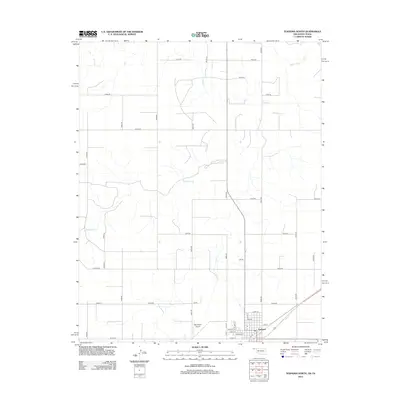
2012 Map of Texhoma North
USGS Topo · Published 2012About this map
Texhoma anchors the southern edge of this Oklahoma Panhandle survey, where the rigid grid of county roads meets the meandering course of the Beaver River. The landscape is defined by its wide, open agricultural reaches, bisected by northern tributaries like Sand Cr and a network of section line roads including Co Hwy-51 and Co Hwy-25. In the town itself, a dense residential street plan featuring Texas St and Main St sits adjacent to the Municipal Airport, reflecting the region's mid-century aviation and infrastructure development. This map captures the intersection of high-plains geography and the structured settlement patterns typical of the Texas County borderlands, illustrating how local transit routes like N0690 Rd facilitate movement across the prairie terrain toward the river basin.
Find a feature on this map
38 named features on this map. Tap any name to fly to it.
Don’t see what you’re looking for? This feature index may not catch every label — zoom into the map to look around manually.
Map Details
Editions of this 2012 Texhoma North Map
This is the sole edition of this map. No revisions or reprints were ever made.
Other maps of this area

1954 · Perryton
USGS Topo · 1:250,000

1958 · Perryton
USGS Topo · 1:250,000

1965 · Stevens
USGS Topo · 1:24,000

1973 · Texhoma NE
USGS Topo · 1:24,000

1973 · Texhoma North
USGS Topo · 1:24,000

1973 · Goodwell NW
USGS Topo · 1:24,000
1973 · Texhoma SW
USGS Topo · 1:24,000
1973 · Texhoma NW
USGS Topo · 1:24,000

1973 · Goodwell
USGS Topo · 1:24,000

1974 · Sunray 1 NW
USGS Topo · 1:24,000