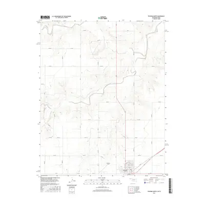
2016 Map of Texhoma North
USGS Topo · Published 2016About this map
Texhoma straddles the southern edge of this Oklahoma Panhandle survey, where the town's street grid is neatly organized around thoroughfares like Court St and Illinois St. The surrounding landscape of Texas County is defined by a dense network of sectional roads, such as Co Rd EE and Co Hwy 51, which crisscross the high plains terrain. The drainage of the Beaver River and its tributary, Sand Creek, introduces topographic relief to an otherwise flat agricultural expanse.
Find a feature on this map
24 named features on this map. Tap any name to fly to it.
Don’t see what you’re looking for? This feature index may not catch every label — zoom into the map to look around manually.
Map Details
Editions of this 2016 Texhoma North Map
This is the sole edition of this map. No revisions or reprints were ever made.
Other maps of this area

1954 · Perryton
USGS Topo · 1:250,000

1958 · Perryton
USGS Topo · 1:250,000

1965 · Stevens
USGS Topo · 1:24,000

1973 · Texhoma NE
USGS Topo · 1:24,000

1973 · Texhoma North
USGS Topo · 1:24,000

1973 · Goodwell NW
USGS Topo · 1:24,000
1973 · Texhoma SW
USGS Topo · 1:24,000
1973 · Texhoma NW
USGS Topo · 1:24,000

1973 · Goodwell
USGS Topo · 1:24,000

1974 · Sunray 1 NW
USGS Topo · 1:24,000