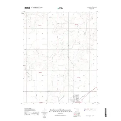
2018 Map of Texhoma North
USGS Topo · Published 2018About this map
Texhoma anchors the southern edge of this Oklahoma Panhandle survey, where the town grid straddles the border region. The landscape is defined by the winding course of the Beaver River, which cuts a prominent valley across the central and northern sections of the quadrangle. This area of Texas County illustrates a classic High Plains settlement pattern, with a rigorous section-line road network, such as Co RD Ee and Co HWY 51, connecting isolated homesteads to the primary hub. North of the city center, the Municipal Airport serves the local aviation needs of this agricultural corridor. Water features are relatively sparse, with Sand Creek feeding into the larger river system, highlighting the vital role of these drainages in an otherwise arid prairie environment. The detailed street plan of the town itself includes thoroughfares like Main St and Elm St, providing a clear record of the community's modern footprint.
Find a feature on this map
34 named features on this map. Tap any name to fly to it.
Don’t see what you’re looking for? This feature index may not catch every label — zoom into the map to look around manually.
Map Details
Editions of this 2018 Texhoma North Map
This is the sole edition of this map. No revisions or reprints were ever made.
Other maps of this area

1954 · Perryton
USGS Topo · 1:250,000

1958 · Perryton
USGS Topo · 1:250,000

1965 · Stevens
USGS Topo · 1:24,000

1973 · Texhoma NE
USGS Topo · 1:24,000

1973 · Texhoma North
USGS Topo · 1:24,000

1973 · Goodwell NW
USGS Topo · 1:24,000
1973 · Texhoma SW
USGS Topo · 1:24,000
1973 · Texhoma NW
USGS Topo · 1:24,000

1973 · Goodwell
USGS Topo · 1:24,000

1974 · Sunray 1 NW
USGS Topo · 1:24,000