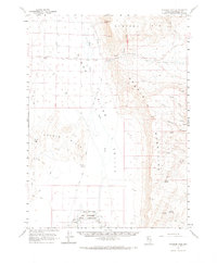
1961 Map of Thacker Pass
USGS Topo · Published 1972About this map
Kings River Valley and the surrounding high desert terrain are defined by the critical water sources that supported livestock and early travel in this part of Humboldt County. The southern portion of the map is dominated by the Quinn River and Quinn River Lakes, adjacent to the northern boundary of the Fort Mc Dermitt Indian Reservation. These permanent water features stand in contrast to the seasonal drainages of the Montana Mountains and the Double H Mountains, where named springs such as Sheep Ranch Springs and Rock Spring provided vital landmarks for ranchers and explorers. Navigation through the complex topography is facilitated by natural gaps like Thacker Pass and Sand Pass, connected by a network of unimproved roads and jeep trails that reflect the area's isolation during the early 1960s.
Find a feature on this map
29 named features on this map. Tap any name to fly to it.
Don’t see what you’re looking for? This feature index may not catch every label — zoom into the map to look around manually.
Map Details
Editions of this 1961 Thacker Pass Map
2 editions found

Other maps of this area

1882 · Paradise
USGS Topo · 1:250,000

1886 · Disaster
USGS Topo · 1:250,000

1893 · Paradise
USGS Topo · 1:250,000

1893 · Disaster
USGS Topo · 1:250,000

1954 · Vya
USGS Topo · 1:250,000

1955 · McDermitt
USGS Topo · 1:250,000

1958 · Vya
USGS Topo · 1:250,000

1958 · Awakening Peak
USGS Topo · 1:62,500

1959 · McDermitt
USGS Topo · 1:250,000

1959 · Orovada
USGS Topo · 1:62,500