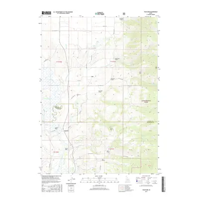
2017 Map of Thatcher
USGS Topo · Published 2017About this map
Thatcher sits at the junction of Wright Rd and E Thatcher Rd, serving as a central point in this agricultural landscape near the Bear River. The terrain is defined by a complex network of water management, featuring the Bench Canal and Gentile Valley Canal, which supported the early 21st-century farming communities of Gentile Valley and Mound Valley. To the north, the settlement of Lago is anchored by the Lago Cem, while the eastern portion of the map transitions into the high elevations of the Cache National Forest. This survey captures a mix of valley irrigation and deep canyon topography, including North Ant Canyon and South Ant Canyon. Local landmarks such as Harris Spring and Bitton Spring dot the foothills, indicating the vital importance of water sources in this region of Franklin County.
Find a feature on this map
54 named features on this map. Tap any name to fly to it.
Don’t see what you’re looking for? This feature index may not catch every label — zoom into the map to look around manually.
Map Details
Editions of this 2017 Thatcher Map
This is the sole edition of this map. No revisions or reprints were ever made.
Other maps of this area

1915 · Preston
USGS Topo · 1:96,000

1918 · Preston
USGS Topo · 1:125,000

1948 · Bancroft
USGS Topo · 1:62,500

1948 · Soda Springs
USGS Topo · 1:62,500

1949 · Bancroft
USGS Topo · 1:62,500

1949 · Soda Springs
USGS Topo · 1:62,500

1955 · Preston
USGS Topo · 1:250,000

1958 · Preston
USGS Topo · 1:250,000

1962 · Preston
USGS Topo · 1:250,000
1969 · Midnight Mtn
USGS Topo · 1:24,000