
1948 Map of Bancroft
USGS Topo · Published 1963About this map
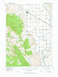
Bannock Co industrial and agricultural development comes into sharp focus in this mid-century topographic record, where the Bear River powers hydroelectric facilities like the Grace Power Plant and Cove Power Plant. The landscape is a network of irrigation, featuring the Soda Canal, West Branch Canal, and Gentile Valley Canal, which support the farming communities of Bancroft, Talmage, and Lund. In the southeast, the complex infrastructure of Penstocks and Surge Tanks near the river contrasts with the family-oriented landmarks of the era, such as the Telluride Sch. The rugged western terrain is dominated by high summits including Petticoat Pk and Sedgwick Pk, while the Union Pacific (Oregon Short Line) railroad cuts through the valley, providing a critical transport artery for the region's mines and crops. Traces of early industrial activity are visible at the Leadville Mine, situated amongst the high ridges and canyons.
Find a feature on this map
64 named features on this map. Tap any name to fly to it.
Don’t see what you’re looking for? This feature index may not catch every label — zoom into the map to look around manually.
Map Details
Editions of this 1948 Bancroft Map
2 editions found
Other maps of this area

1914 · Henry
USGS Topo · 1:48,000

1915 · Preston
USGS Topo · 1:96,000

1916 · Henry
USGS Topo · 1:62,500

1917 · Portneuf
USGS Topo · 1:62,500

1918 · Preston
USGS Topo · 1:125,000

1948 · Soda Springs
USGS Topo · 1:62,500

1949 · Bancroft
USGS Topo · 1:62,500

1949 · Soda Springs
USGS Topo · 1:62,500

1954 · Pocatello
USGS Topo · 1:250,000

1955 · Preston
USGS Topo · 1:250,000