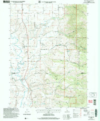
2005 Map of Thatcher
USGS Topo · Published 2007About this map
Gentile Valley and Mound Valley anchor this mid-2000s survey of southeastern Idaho, where the meandering Bear River carves a path through a landscape of high-elevation basins and steep forest ridges. The small settlement of Thatcher sits near the river's edge, characterized by the Thatcher Central High School, while to the north, the community of Lago and the Lago Cem represent the area's established rural infrastructure. The mapping reveals a complex water system, including the Grace Fish Hatchery and numerous mountain springs like Harris Spring and Thimbleberry Spring. The eastern portion of the quadrangle is dominated by the steep terrain of the Caribou National Forest and Cache National Forest, featuring deep drainages such as Cheatbeck Canyon and the notable Hell Hole. This era of the map captures the region's transition, documenting specific land use from the Gravel Pit to the network of unpaved forest roads like Ant Canyon Road.
Find a feature on this map
46 named features on this map. Tap any name to fly to it.
Don’t see what you’re looking for? This feature index may not catch every label — zoom into the map to look around manually.
Map Details
Editions of this 2005 Thatcher Map
This is the sole edition of this map. No revisions or reprints were ever made.
Other maps of this area

1915 · Preston
USGS Topo · 1:96,000

1918 · Preston
USGS Topo · 1:125,000

1948 · Bancroft
USGS Topo · 1:62,500

1948 · Soda Springs
USGS Topo · 1:62,500

1949 · Bancroft
USGS Topo · 1:62,500

1949 · Soda Springs
USGS Topo · 1:62,500

1955 · Preston
USGS Topo · 1:250,000

1958 · Preston
USGS Topo · 1:250,000

1962 · Preston
USGS Topo · 1:250,000
1969 · Midnight Mtn
USGS Topo · 1:24,000