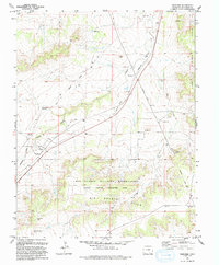
1993 Map of Thatcher
USGS Topo · Published 1993About this map
The Historic Santa Fe National Trail cuts a diagonal path across this high plains landscape, illustrating the enduring legacy of 19th-century western migration routes through Las Animas County. In the southern portion of the map, the Fort Carson Military Reservation (Piñon Canyon Maneuver Site) encompasses a significant expanse of terrain including the Big Arroyo Hills and the winding Big Arroyo. The settlement of Thatcher serves as a local focal point near the Timpas Creek drainage, while the nearby Old Railroad Grade and Houghton reflect the area's historical transportation infrastructure. Notable landmarks like Tater Hill and the Bear Springs Hills define the topography, which is further marked by ranching features such as the Double Tank Windmill and various water tanks essential for life in this arid region.
Find a feature on this map
23 named features on this map. Tap any name to fly to it.
Don’t see what you’re looking for? This feature index may not catch every label — zoom into the map to look around manually.
Map Details
Editions of this 1993 Thatcher Map
This is the sole edition of this map. No revisions or reprints were ever made.
Other maps of this area

1891 · Timpas
USGS Topo · 1:125,000

1891 · Apishapa
USGS Topo · 1:125,000

1891 · Mesa De Maya
USGS Topo · 1:125,000

1892 · Elmoro
USGS Topo · 1:125,000

1893 · Apishapa
USGS Topo · 1:125,000

1893 · Elmoro
USGS Topo · 1:125,000

1893 · Mesa de Maya
USGS Topo · 1:125,000

1894 · Timpas
USGS Topo · 1:125,000

1897 · Elmoro
USGS Topo · 1:125,000

1897 · Apishapa
USGS Topo · 1:125,000