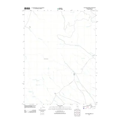
2012 Map of Thatcher Spring
USGS Topo · Published 2012About this map
Sod House Ranch and Indian Ranch anchor this landscape in the northern Cortez Mountains, illustrating the persistent role of cattle ranching in the high desert of Eureka County. The terrain is defined by a sophisticated network of spring-fed drainages, including the series of Florio Spring Number Two through Florio Spring Number Seven, which provide vital water sources in this arid environment. These springs feed into systems like Doc Creek and Linka Creek, eventually reaching larger channels such as Sod House Creek and Big Pole Creek. The presence of Buckhorn Ranch Rd indicates the primary transit corridor through the region, connecting isolated settlements like Hall Ranch with the broader central Nevada range. From the heights of Sheep Creek Canyon to the alluvial flats, the map documents a territory where geography and hydrology dictate the footprint of human habitation.
Find a feature on this map
25 named features on this map. Tap any name to fly to it.
Don’t see what you’re looking for? This feature index may not catch every label — zoom into the map to look around manually.
Map Details
Editions of this 2012 Thatcher Spring Map
This is the sole edition of this map. No revisions or reprints were ever made.
Other maps of this area

1937 · Mineral Hill
USGS Topo · 1:48,000

1943 · Mineral Hill
USGS Topo · 1:62,500

1952 · Pine Valley
USGS Topo · 1:62,500

1955 · Winnemucca
USGS Topo · 1:250,000

1957 · Frenchie Creek
USGS Topo · 1:62,500

1957 · Horse Creek Valley
USGS Topo · 1:62,500

1958 · Winnemucca
USGS Topo · 1:250,000

1962 · Winnemucca
USGS Topo · 1:250,000
1985 · Thatcher Spring
USGS Topo · 1:24,000
1985 · Hand-Me-Down Creek
USGS Topo · 1:24,000