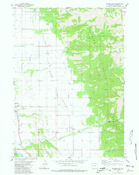
1980 Map of Thayne East
USGS Topo · Published 1981About this map
Star Valley irrigation systems define this 1980 landscape, where the Bedford Canal, Hardman Ditch, and East Side Canal distribute water across the valley floor. In the town of Thayne, a small Golf Course and the Holdaway Sch serve the local community, while the nearby settlement of Bedford sits at the mouth of Strawberry Creek. The map documents a clear transition from the managed agricultural lands of the valley to the protected wilderness of the Bridger National Forest, which covers the eastern half of the sheet with numerous canyons including Prater Canyon and Green Canyon. The presence of a Substa and Power Plant near Bedford indicates the infrastructure required for this corner of Lincoln County as it appeared in the early 1980s.
Find a feature on this map
36 named features on this map. Tap any name to fly to it.
Don’t see what you’re looking for? This feature index may not catch every label — zoom into the map to look around manually.
Map Details
Editions of this 1980 Thayne East Map
This is the sole edition of this map. No revisions or reprints were ever made.
Other maps of this area

1915 · Freedom
USGS Topo · 1:62,500

1921 · Afton
USGS Topo · 1:125,000

1931 · Jackson
USGS Topo · 1:125,000

1932 · Irwin
USGS Topo · 1:96,000

1935 · Irwin
USGS Topo · 1:125,000

1935 · Jackson
USGS Topo · 1:125,000

1955 · Driggs
USGS Topo · 1:250,000

1955 · Preston
USGS Topo · 1:250,000

1958 · Driggs
USGS Topo · 1:250,000

1958 · Preston
USGS Topo · 1:250,000