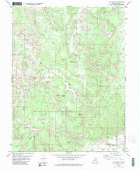
1983 Map of The Blocks
USGS Topo · Published 1983About this map
Head of Sinbad and the high desert plateaus of central Utah define this landscape as it was documented in the mid-1970s. The area is characterized by a complex network of canyons and washes, most notably McCarty Canyon, Cane Wash, and the various forks of Coal Wash. Named for its distinct geological formations, the sheet features landmarks such as The Blocks, Devils Monument, and the whimsical Joe and His Dog. These names, along with The Twin Priests and Golden Gate, reflect the interpretive history of those who first navigated this terrain.
Find a feature on this map
26 named features on this map. Tap any name to fly to it.
Don’t see what you’re looking for? This feature index may not catch every label — zoom into the map to look around manually.
Map Details
Editions of this 1983 The Blocks Map
2 editions found
Other maps of this area

1885 · San Rafael
USGS Topo · 1:250,000

1886 · Price River
USGS Topo · 1:250,000

1896 · Price River
USGS Topo · 1:250,000

1952 · San Rafael Knob
USGS Topo · 1:62,500

1953 · Stinking Spring Creek 2 SE
USGS Topo · 1:24,000

1953 · Wilsonville SE
USGS Topo · 1:24,000

1953 · Red Plateau SW
USGS Topo · 1:24,000

1954 · Stinking Spring Creek 1 NW
USGS Topo · 1:24,000

1954 · Stinking Spring Creek 2 SW
USGS Topo · 1:24,000

1954 · Stinking Spring Creek 2 NE
USGS Topo · 1:24,000