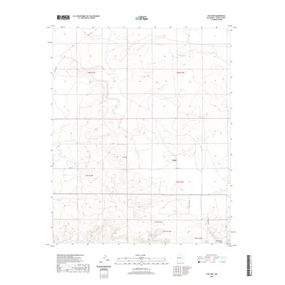
2020 Map of The Dyke
USGS Topo · Published 2020About this map
Tingle sits at the heart of this high-plateau landscape in Cibola County, where seasonal watercourses define the geography of the high desert. The prominent geological formation known as The Dyke cuts through the center of the sheet, while drainage patterns like Jaralosa Draw and Pascual Draw converge to the south near Puertocito Draw. In the northern reaches, Jaramie Lake and the winding Lorenzo Arroyo highlight the region's scattered water resources. The road network, including Pine Hill Rd and Co Rd 35 D, reflects a modern rural infrastructure designed around the natural contours and ancient townships of western New Mexico.
Find a feature on this map
17 named features on this map. Tap any name to fly to it.
Don’t see what you’re looking for? This feature index may not catch every label — zoom into the map to look around manually.
Map Details
Editions of this 2020 The Dyke Map
This is the sole edition of this map. No revisions or reprints were ever made.
Other maps of this area

1954 · Saint Johns
USGS Topo · 1:250,000

1957 · Saint Johns
USGS Topo · 1:250,000

1958 · Saint Johns
USGS Topo · 1:250,000

1962 · Saint Johns
USGS Topo · 1:250,000

1967 · Red Lake Mission
USGS Topo · 1:24,000

1967 · Chimney Hill
USGS Topo · 1:24,000
1967 · Techado
USGS Topo · 1:24,000

1972 · Fence Lake
USGS Topo · 1:24,000
1972 · Cerro Prieto
USGS Topo · 1:24,000

1972 · Fence Lake SW
USGS Topo · 1:24,000