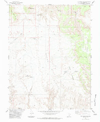
1983 Map of The Frying Pan
USGS Topo · Published 1983About this map
Cedar Mountain and the surrounding high desert plateaus of the Emery Co and Wayne Co border dominate this landscape in the early 1980s. The area is defined by its critical water management infrastructure, where isolation necessitated the construction of the Horse Heaven Reservoir and specialized collection points like the Frying Pan Catchment and Moroni Slope Catchment. These features reflect the adaptive land use required for ranching and resource extraction in the San Rafael Swell region.
Find a feature on this map
22 named features on this map. Tap any name to fly to it.
Don’t see what you’re looking for? This feature index may not catch every label — zoom into the map to look around manually.
Map Details
Editions of this 1983 The Frying Pan Map
3 editions found
Other maps of this area

1885 · San Rafael
USGS Topo · 1:250,000

1885 · Fish Lake
USGS Topo · 1:250,000

1896 · Fish Lake
USGS Topo · 1:250,000

1952 · Wild Horse
USGS Topo · 1:62,500

1953 · Emery 4 NE
USGS Topo · 1:24,000

1953 · Emery 4 SE
USGS Topo · 1:24,000

1954 · Stinking Spring Creek 3 NW
USGS Topo · 1:24,000

1954 · Stinking Spring Creek 3 SW
USGS Topo · 1:24,000

1954 · Mt. Ellen 2 NW
USGS Topo · 1:24,000

1954 · Notom 1 NE
USGS Topo · 1:24,000