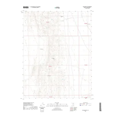
2018 Map of The Gouge Eye
USGS Topo · Published 2018About this map
The Fortification Range dominates this corner of Lincoln County, defining a landscape shaped by narrow canyons and isolated water sources. Named for its distinctive topography, The Gouge Eye sits at the heart of this high-desert terrain, where seasonal drainages like Smiley Canyon and Cottonwood Canyon carve through the ridges. The scarcity of water in this arid environment is evident by the scattered locations of vital points such as Gouge Eye Spring, Wild Horse Spring, and Cow Heaven Spring. To the east, the land opens into Spring Valley, showing the transition from the vertical relief of the mountains to the broader valley floor. This survey documents the complex system of springs, including Fortification Spring and Poor Cow Spring, that have historically sustained life and livestock in this remote section of Nevada.
Find a feature on this map
19 named features on this map. Tap any name to fly to it.
Don’t see what you’re looking for? This feature index may not catch every label — zoom into the map to look around manually.
Map Details
Editions of this 2018 The Gouge Eye Map
This is the sole edition of this map. No revisions or reprints were ever made.
Other maps of this area

1956 · Lund
USGS Topo · 1:250,000

1960 · Lund
USGS Topo · 1:250,000

1973 · Gouge Eye Well
USGS Topo · 1:24,000

1973 · Horse Corral Pass
USGS Topo · 1:24,000

1973 · Atlanta
USGS Topo · 1:24,000

1973 · Indian Springs Knolls
USGS Topo · 1:24,000
1973 · Mustang Well
USGS Topo · 1:24,000
1973 · Mount Grafton NE
USGS Topo · 1:24,000

1973 · Red Ledges
USGS Topo · 1:24,000
1973 · Wells Summit
USGS Topo · 1:24,000