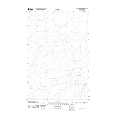
2011 Map of The Horse Ranch
USGS Topo · Published 2011About this map
The Horse Ranch serves as a central landmark in this portion of Fergus County, where livestock and water management define the landscape. The geography is carved by a network of drainage systems, including Rose Creek, Cottonwood Creek, and the winding Armells Creek to the south. Management of these water resources is evidenced by significant local infrastructure such as the Taylor Reservoir Dam, Taylor Fish Dam, and Armells Reservoir Dam.
Find a feature on this map
12 named features on this map. Tap any name to fly to it.
Don’t see what you’re looking for? This feature index may not catch every label — zoom into the map to look around manually.
Map Details
Editions of this 2011 The Horse Ranch Map
This is the sole edition of this map. No revisions or reprints were ever made.
Other maps of this area

1954 · Lewistown
USGS Topo · 1:250,000

1959 · Lewistown
USGS Topo · 1:250,000

1978 · Lewistown
USGS Topo · 1:100,000

1985 · The Horse Ranch
USGS Topo · 1:24,000

1985 · Fergus
USGS Topo · 1:24,000

1985 · Hilger
USGS Topo · 1:24,000
1985 · Christina
USGS Topo · 1:24,000

1985 · Armells
USGS Topo · 1:24,000
1985 · Gerhard Corner
USGS Topo · 1:24,000
1985 · Winifred East
USGS Topo · 1:24,000