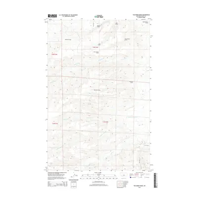
2014 Map of The Horse Ranch
USGS Topo · Published 2014About this map
The Horse Ranch sits as the central namesake of this high-plains landscape in Fergus County, surrounded by a complex system of drainage coulees and seasonal creeks. The terrain is deeply etched by water, with Deadman Coulee and Burnshed Coulee cutting through the northern sections, while Cottonwood Creek and its South Fork define the southern reaches. This 2014 survey reveals a sparsely populated ranching territory where local infrastructure is limited to fundamental arteries like Butcher Road and Horse Ranch Road. The transition from Rose Creek in the northwest to Armells Creek in the south illustrates the subtle but critical watershed patterns that dictate life and land use in this part of Montana. The naming conventions—including Burnt Timber Coulee and Murphy Coulee—point to a landscape shaped by both natural events and the families who settled this open country.
Find a feature on this map
17 named features on this map. Tap any name to fly to it.
Don’t see what you’re looking for? This feature index may not catch every label — zoom into the map to look around manually.
Map Details
Editions of this 2014 The Horse Ranch Map
This is the sole edition of this map. No revisions or reprints were ever made.
Other maps of this area

1954 · Lewistown
USGS Topo · 1:250,000

1959 · Lewistown
USGS Topo · 1:250,000

1978 · Lewistown
USGS Topo · 1:100,000

1985 · The Horse Ranch
USGS Topo · 1:24,000

1985 · Fergus
USGS Topo · 1:24,000

1985 · Hilger
USGS Topo · 1:24,000
1985 · Christina
USGS Topo · 1:24,000

1985 · Armells
USGS Topo · 1:24,000
1985 · Gerhard Corner
USGS Topo · 1:24,000
1985 · Winifred East
USGS Topo · 1:24,000