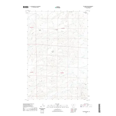
2020 Map of The Horse Ranch
USGS Topo · Published 2020About this map
Armells Creek and the S Fork Cottonwood Cr flow through this section of Fergus County, where the high plains are deeply incised by a network of seasonal drainages. This landscape is defined by its ranching heritage, centered on the eponymous The Horse Ranch near the southern boundary. The drainage patterns revealed here, including Deadman Coulee, Burnshed Coulee, and Burnt Timber Coulee, dictate the path of local travel along routes like Horse Ranch Rd and E Suffolk Rd. These coulees provide natural corridors through the dissected terrain, illustrating how topography has shaped the placement of rural homesteads and cattle operations in this part of Montana. The map provides a contemporary view of these land divisions, including the township boundaries of T20N R20E and T19N R20E, which continue to organize the remote agricultural reaches of the state.
Find a feature on this map
18 named features on this map. Tap any name to fly to it.
Don’t see what you’re looking for? This feature index may not catch every label — zoom into the map to look around manually.
Map Details
Editions of this 2020 The Horse Ranch Map
This is the sole edition of this map. No revisions or reprints were ever made.
Other maps of this area

1954 · Lewistown
USGS Topo · 1:250,000

1959 · Lewistown
USGS Topo · 1:250,000

1978 · Lewistown
USGS Topo · 1:100,000

1985 · The Horse Ranch
USGS Topo · 1:24,000

1985 · Fergus
USGS Topo · 1:24,000

1985 · Hilger
USGS Topo · 1:24,000
1985 · Christina
USGS Topo · 1:24,000

1985 · Armells
USGS Topo · 1:24,000
1985 · Gerhard Corner
USGS Topo · 1:24,000
1985 · Winifred East
USGS Topo · 1:24,000