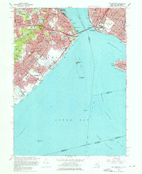
1966 Map of The Narrows
USGS Topo · Published 1976About this map
Fort Wadsworth and Fort Hamilton stand as coastal guardians on either side of the waterway in the mid-1960s, connected by the newly completed Verrazano-Narrows Bridge. This survey captures the dense residential fabric of eastern Staten Island and southwest Brooklyn, where neighborhoods like Stapleton, Rosebank, and Bayview (near Bath Beach) are interwoven with extensive parklands and institutional grounds. The topographic detail highlights the significant elevation of Todt Hill and Emerson Hill, providing a clear view of the transition from these heights down to the sprawling shoreline developments of Midland Beach and South Beach. Inland, the massive Moravian Cemetery and the Vanderbilt Mausoleum anchor the local geography near Dongan Hills. The maritime significance of the region is evident in the charting of the Ambrose Channel and the West Bank Lighthouse, which guide traffic through Lower Bay toward the harbor.
Find a feature on this map
110 named features on this map. Tap any name to fly to it.
Don’t see what you’re looking for? This feature index may not catch every label — zoom into the map to look around manually.
Map Details
Editions of this 1966 The Narrows Map
4 editions found
Other maps of this area

1888 · Sandy Hook
USGS Topo · 1:62,500

1889 · Brooklyn
USGS Topo · 1:62,500

1891 · Brooklyn
USGS Topo · 1:62,500

1893 · Sandy Hook
USGS Topo · 1:62,500

1897 · Brooklyn
USGS Topo · 1:62,500

1898 · Staten Island
USGS Topo · 1:62,500

1898 · Brooklyn
USGS Topo · 1:62,500

1900 · Passaic
USGS Topo · 1:125,000

1900 · Staten Island
USGS Topo · 1:62,500

1900 · Brooklyn
USGS Topo · 1:62,500