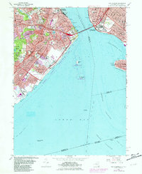
1966 Map of The Narrows
USGS Topo · Published 1982About this map
The Narrows serves as the focal point for this survey of the gateway to New York Harbor, where the massive Verrazano-Narrows Bridge links Fort Hamilton in Brooklyn to Fort Wadsworth on Staten Island. The urban landscape of the late sixties is visible in the dense network of neighborhoods like Stapleton, Rosebank, and New Dorp, served by the Staten Island Rapid Transit line. Extensive green spaces and institutions characterize the interior heights, including the sprawling Moravian Cemetery, Grymes Hill, and Wagner College. Along the shoreline, the transition from military and industrial use to public recreation is evident in the inclusion of the Gateway National Recreation Area, covering Miller Field and offshore features like Hoffman Island. To the east, the map details the western edge of Coney Island and the strategic Ambrose Channel, essential for the maritime commerce entering the city.
Find a feature on this map
142 named features on this map. Tap any name to fly to it.
Don’t see what you’re looking for? This feature index may not catch every label — zoom into the map to look around manually.
Map Details
Editions of this 1966 The Narrows Map
4 editions found
Other maps of this area

1888 · Sandy Hook
USGS Topo · 1:62,500

1889 · Brooklyn
USGS Topo · 1:62,500

1891 · Brooklyn
USGS Topo · 1:62,500

1893 · Sandy Hook
USGS Topo · 1:62,500

1897 · Brooklyn
USGS Topo · 1:62,500

1898 · Staten Island
USGS Topo · 1:62,500

1898 · Brooklyn
USGS Topo · 1:62,500

1900 · Passaic
USGS Topo · 1:125,000

1900 · Staten Island
USGS Topo · 1:62,500

1900 · Brooklyn
USGS Topo · 1:62,500