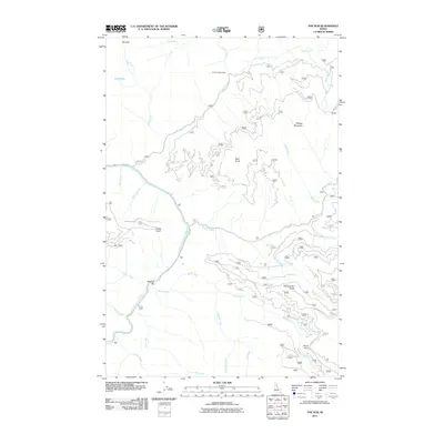
2011 Map of The Nub
USGS Topo · Published 2011About this map
North Fork Clearwater River carves through this part of Clearwater County, shaping a landscape defined by deep drainages and prominent ridges. Near the river's bend, Moscow Bar and the elevated Moscow Bar Ridge suggest a history of riparian activity, while the presence of Collins Creek Cabin to the north points toward the area's utility for forestry or remote habitation. The terrain is marked by high points like The Nub, Wallow Mountain, and Bald Knob, which overlook a dense network of watercourses including Skull Creek, Quartz Creek, and Rock Creek. These waterways and the forest roads like Co RD 252 and Co RD 711 illustrate how this part of the Idaho wilderness was accessed and managed in the early 21st century, providing a clear record of the geographic landmarks used by local travelers and outdoorsmen.
Find a feature on this map
32 named features on this map. Tap any name to fly to it.
Don’t see what you’re looking for? This feature index may not catch every label — zoom into the map to look around manually.
Map Details
Editions of this 2011 The Nub Map
This is the sole edition of this map. No revisions or reprints were ever made.
Other maps of this area

1911 · Lolo
USGS Topo · 1:250,000

1913 · Lolo
USGS Topo · 1:250,000

1923 · Washington Creek
USGS Topo · 1:125,000

1956 · Hamilton
USGS Topo · 1:250,000

1959 · Hamilton
USGS Topo · 1:250,000

1960 · Hamilton
USGS Topo · 1:250,000
1963 · Mallard Peak
USGS Topo · 1:24,000

1963 · Sheep Mtn
USGS Topo · 1:24,000
1963 · Pole Mtn
USGS Topo · 1:24,000
1963 · The Nub
USGS Topo · 1:24,000