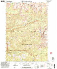
2000 Map of The Pyramid
USGS Topo · Published 2005About this map
The Pyramid stands as a prominent landmark in this high-altitude landscape of Park County, Montana, situated within the Gallatin National Forest. This mapping revision from the year 2000 documents the complex drainage systems and protected lands of the Absaroka-Beartooth Wilderness. The area is defined by its dramatic water features, including Elbow Lake and Crystal Lake, which feed a network of waterways such as Mill Creek and its East Fork.
Find a feature on this map
20 named features on this map. Tap any name to fly to it.
Don’t see what you’re looking for? This feature index may not catch every label — zoom into the map to look around manually.
Map Details
Editions of this 2000 The Pyramid Map
This is the sole edition of this map. No revisions or reprints were ever made.
Other maps of this area

1891 · Livingston
USGS Topo · 1:250,000

1893 · Livingston
USGS Topo · 1:250,000

1940 · Mt. Cowen
USGS Topo · 1:62,500

1940 · Mt Wallace
USGS Topo · 1:62,500

1943 · Mt Wallace
USGS Topo · 1:62,500

1943 · Mt Cowen
USGS Topo · 1:62,500

1947 · Bozeman
USGS Topo · 1:250,000

1948 · Bozeman
USGS Topo · 1:250,000

1955 · Bozeman
USGS Topo · 1:250,000

1955 · Emigrant
USGS Topo · 1:62,500