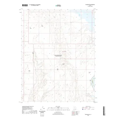
2020 Map of The Rincon NE
USGS Topo · Published 2020About this map
The Glen Canyon National Recreation Area dominates this landscape where the high desert meets the backwaters of the Colorado River. A complex network of drainage systems, including Bowns Canyon, Fence Canyon, and Cow Canyon, carves through the sandstone toward the sunken channels of Lake Powell. This survey highlights the dramatic geological transition at the Water Pocket Fold, a massive monocline that defines the local topography alongside features like Iron Top Mesa.
Find a feature on this map
13 named features on this map. Tap any name to fly to it.
Don’t see what you’re looking for? This feature index may not catch every label — zoom into the map to look around manually.
Map Details
Editions of this 2020 The Rincon NE Map
This is the sole edition of this map. No revisions or reprints were ever made.
Other maps of this area

1886 · Henry Mountains
USGS Topo · 1:250,000

1892 · Henry Mountains
USGS Topo · 1:250,000

1953 · Mt Pennell 3 SW
USGS Topo · 1:24,000

1953 · The Rincon
USGS Topo · 1:62,500

1953 · Lake Canyon
USGS Topo · 1:62,500

1953 · Mt. Ellsworth
USGS Topo · 1:62,500

1953 · Hall Mesa
USGS Topo · 1:62,500

1956 · Escalante
USGS Topo · 1:250,000

1960 · Escalante
USGS Topo · 1:250,000
1980 · Hite Crossing
USGS Topo · 1:100,000