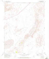
1968 Map of The Wall
USGS Topo · Published 1972About this map
Lunar Lake and the volcanic expanse of Lava dominate this late 1960s desert landscape, mapped in cooperation with the Atomic Energy Commission. The topography is defined by the sharp verticality of The Pancake Range and the distinctive formation known as The Wall, which divides the high desert terrain. Water, while scarce, is traced through the long corridor of Sand Springs Wash as it descends into Big Sand Springs Valley. Human activity in this desolate stretch of Nye County is marked primarily by extraction and transit, from the scattered Prospects and a Cinder Pit to the winding Jeep Trail that navigates the eastern slopes toward Railroad Valley. The map records a primitive infrastructure of fence lines and remote landmarks like Black Rock in a region defined by its geological starkness.
Find a feature on this map
11 named features on this map. Tap any name to fly to it.
Don’t see what you’re looking for? This feature index may not catch every label — zoom into the map to look around manually.
Map Details
Editions of this 1968 The Wall Map
This is the sole edition of this map. No revisions or reprints were ever made.
Other maps of this area

1956 · Lund
USGS Topo · 1:250,000

1956 · Tonopah
USGS Topo · 1:250,000

1959 · Tonopah
USGS Topo · 1:250,000

1960 · Lund
USGS Topo · 1:250,000

1962 · Tonopah
USGS Topo · 1:250,000

1967 · Lunar Crater
USGS Topo · 1:62,500

1967 · Moores Station
USGS Topo · 1:62,500

1967 · Moores Station SE
USGS Topo · 1:24,000

1967 · Lunar Crater
USGS Topo · 1:24,000
1967 · Chuck Wagon Flat
USGS Topo · 1:24,000