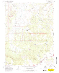
1983 Map of The Wickiup
USGS Topo · Published 1983About this map
The Wickiup rises as the central landmark in this 1983 survey of Emery County, Utah, where a network of drainage draws and high benches defines the landscape. The map captures a high-desert environment shaped by water management and resource exploration, featuring multiple specialized water sources such as Sids Holes, Cottonwood Holes, and the Mexican Seep. The presence of Round Knoll Pond and Road Hollow Reservoir suggests the importance of water catchment for livestock or industrial use in this arid region.
Find a feature on this map
31 named features on this map. Tap any name to fly to it.
Don’t see what you’re looking for? This feature index may not catch every label — zoom into the map to look around manually.
Map Details
Editions of this 1983 The Wickiup Map
This is the sole edition of this map. No revisions or reprints were ever made.
Other maps of this area

1885 · San Rafael
USGS Topo · 1:250,000

1886 · Price River
USGS Topo · 1:250,000

1896 · Price River
USGS Topo · 1:250,000

1952 · San Rafael Knob
USGS Topo · 1:62,500

1953 · Stinking Spring Creek 2 SE
USGS Topo · 1:24,000

1953 · Wilsonville SE
USGS Topo · 1:24,000

1953 · Red Plateau SE
USGS Topo · 1:24,000

1953 · Red Plateau SW
USGS Topo · 1:24,000

1954 · Stinking Spring Creek 1 SE
USGS Topo · 1:24,000

1954 · Stinking Spring Creek 1 NW
USGS Topo · 1:24,000