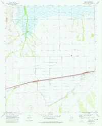
1973 Map of Theba
USGS Topo · Published 1976About this map
The Southern Pacific railroad corridor dominates this mid-1970s desert landscape, cutting a straight line through the irrigated fields of the Gila River valley. Centered on the settlement of Theba, the map illustrates an era of intensive agricultural development facilitated by a complex network of irrigation channels, including Lateral A and Lateral B. Near the western edge of the quadrangle, the small siding of Piedra is noted alongside a Cem and a system of secondary desert tracks such as Sisson Road and Painted Rock Road. The topography reveals the transition from the flat agricultural basins of the Gila River Ranch to the more open desert, where features like a Corral and a Landing Field suggest the area's dual reliance on ranching and localized transport.
Find a feature on this map
17 named features on this map. Tap any name to fly to it.
Don’t see what you’re looking for? This feature index may not catch every label — zoom into the map to look around manually.
Map Details
Editions of this 1973 Theba Map
This is the sole edition of this map. No revisions or reprints were ever made.
Other maps of this area

1942 · Vicksburg
USGS Topo · 1:250,000

1949 · Sentinel
USGS Topo · 1:62,500

1950 · Sentinel
USGS Topo · 1:62,500

1950 · Theba
USGS Topo · 1:62,500

1951 · Theba
USGS Topo · 1:62,500

1951 · Dendora Valley
USGS Topo · 1:62,500

1951 · Woolsey Peak
USGS Topo · 1:62,500

1953 · Ajo
USGS Topo · 1:250,000

1954 · Phoenix
USGS Topo · 1:250,000

1957 · Ajo
USGS Topo · 1:250,000