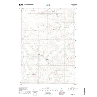
2019 Map of Theilman
USGS Topo · Published 2019About this map
Theilman sits at the heart of this landscape where the Zumbro River snakes through deeply incised valleys. The area is defined by a series of dramatic coulees, such as Sutton Coulee, Rattler Coulee, and Bade Coulee, which channel drainage from the surrounding high plateaus down toward the river basin. For genealogists and local historians, the Scott Settlement Cem in the northwest serves as a significant marker of early regional habitation. The geography is further articulated by numerous waterways including Middle Cr, W Indian Cr, and Trout Brook. Notable landforms like Foley Mound rise above the river bends, while a network of rural roads like Co RD 4 and Co RD 86 connect the scattered farmsteads and agricultural lands that occupy the level ground between the coulee breaks.
Find a feature on this map
67 named features on this map. Tap any name to fly to it.
Don’t see what you’re looking for? This feature index may not catch every label — zoom into the map to look around manually.
Map Details
Editions of this 2019 Theilman Map
This is the sole edition of this map. No revisions or reprints were ever made.
Other maps of this area

1932 · Wabasha
USGS Topo · 1:62,500

1934 · Plainview
USGS Topo · 1:62,500

1935 · Rochester
USGS Topo · 1:48,000

1938 · Plainview
USGS Topo · 1:62,500

1939 · Rochester
USGS Topo · 1:62,500

1951 · Wabasha
USGS Topo · 1:62,500

1951 · Lake City
USGS Topo · 1:62,500

1953 · Saint Paul
USGS Topo · 1:250,000

1959 · Saint Paul
USGS Topo · 1:250,000
1972 · Plainview
USGS Topo · 1:24,000