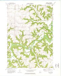
1974 Map of Theilman
USGS Topo · Published 1976About this map
Theilman sits at a bend in the Zumbro River within a landscape defined by deep coulees and wooded ridges in the 1970s. The terrain here is dominated by the Minnesota Memorial Hardwood State Forest and the Zumbro State Wildlife Management Area, showing a region heavily managed for conservation and natural resources. Notable local landmarks include the Scott Settlement Cem and the distinctive Foley Mound, while numerous waterways like Bade Coulee and Indian Creek carve through the upland areas of West Albany and Highland. The presence of several sandpits, gravel pits, and a Quarry indicates the active extraction of local materials, while the Pipeline corridor and various campgrounds suggest the integration of industrial infrastructure and recreational use in this river valley environment.
Find a feature on this map
34 named features on this map. Tap any name to fly to it.
Don’t see what you’re looking for? This feature index may not catch every label — zoom into the map to look around manually.
Map Details
Editions of this 1974 Theilman Map
This is the sole edition of this map. No revisions or reprints were ever made.
Other maps of this area

1932 · Wabasha
USGS Topo · 1:62,500

1934 · Plainview
USGS Topo · 1:62,500

1935 · Rochester
USGS Topo · 1:48,000

1938 · Plainview
USGS Topo · 1:62,500

1939 · Rochester
USGS Topo · 1:62,500

1951 · Wabasha
USGS Topo · 1:62,500

1951 · Lake City
USGS Topo · 1:62,500

1953 · Saint Paul
USGS Topo · 1:250,000

1959 · Saint Paul
USGS Topo · 1:250,000
1972 · Plainview
USGS Topo · 1:24,000