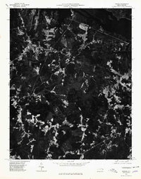
1976 Map of Thelma
USGS Topo · Published 1979About this map
Lake Gaston dominates the northern border of this landscape, its waters filling the Roanoke River valley as it appeared in the mid-1970s. This orthophotoquad reveals the intricate patterns of timber tracts and agricultural clearings that define the region south of the reservoir. Small rural clusters serve as the primary landmarks for local history, including Summit and the crossroads community of Thelma. The map provides a photographic record of land use before subsequent decades of development, showing the transition from dense forest to cultivated fields.
Find a feature on this map
5 named features on this map. Tap any name to fly to it.
Don’t see what you’re looking for? This feature index may not catch every label — zoom into the map to look around manually.
Map Details
Editions of this 1976 Thelma Map
This is the sole edition of this map. No revisions or reprints were ever made.
Other maps of this area

1919 · White Plains
USGS Topo · 1:48,000

1919 · Emporia
USGS Topo · 1:62,500

1920 · White Plains
USGS Topo · 1:62,500

1942 · Emporia
USGS Topo · 1:62,500

1953 · Norfolk
USGS Topo · 1:250,000

1963 · Barley
USGS Topo · 1:24,000

1963 · Gasburg
USGS Topo · 1:24,000

1963 · Valentines
USGS Topo · 1:24,000

1973 · Aurelian Springs
USGS Topo · 1:24,000

1973 · Hollister
USGS Topo · 1:24,000