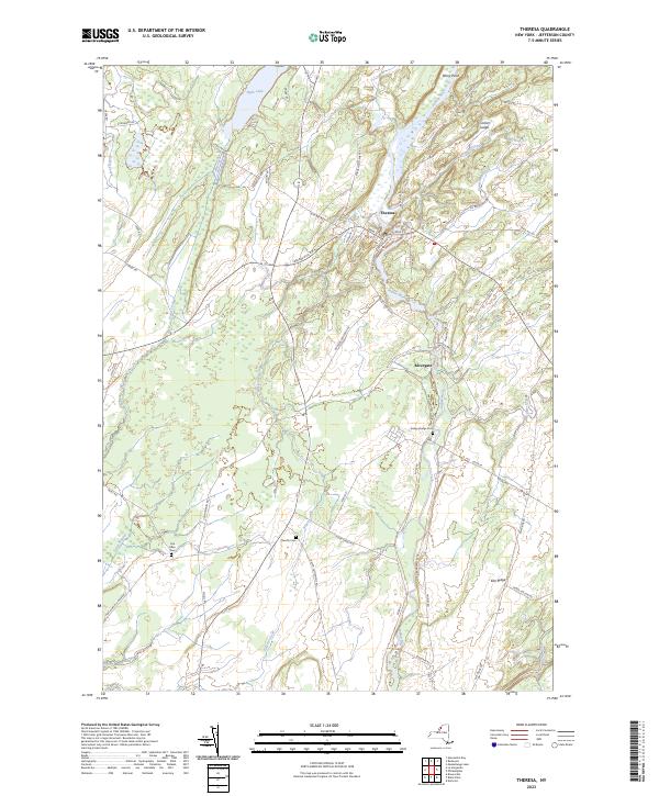
2023 Map of Theresa
USGS Topo · Published 2023About this map
The Indian River winds sharply through this Jefferson County landscape, anchoring the village of Theresa where a network of local streets like Main St, Mill St, and Riverside Ave concentrate near the river's bend. The terrain is defined by a series of distinct elevations and water bodies, including the prominent Corbin Ledge to the northeast and Hyde Lake in the northwest. Local history is etched into the land through family-named landmarks and cemeteries, such as the Van Allen Cem and Chaufty Cem, which sit alongside a network of rural roads that follow the natural contours of the drainage basins. South of the main village, the small settlement of Rivergate marks a secondary point of activity near the confluence of several local routes. This modern survey illustrates how long-established rural road patterns, like English Settlement Rd and Dutch Settlement Rd, continue to define the spatial organization of the community.
Find a feature on this map
65 named features on this map. Tap any name to fly to it.
Don’t see what you’re looking for? This feature index may not catch every label — zoom into the map to look around manually.
Map Details
Editions of this 2023 Theresa Map
This is the sole edition of this map. No revisions or reprints were ever made.
Other maps of this area

1903 · Alexandria Bay
USGS Topo · 1:62,500

1903 · Theresa
USGS Topo · 1:62,500

1911 · Antwerp
USGS Topo · 1:62,500

1912 · Hammond
USGS Topo · 1:62,500

1943 · Redwood
USGS Topo · 1:31,680

1943 · Lafargeville
USGS Topo · 1:31,680
1943 · Brownville
USGS Topo · 1:31,680

1943 · Alexandria Bay
USGS Topo · 1:31,680

1944 · Hammond
USGS Topo · 1:62,500

1948 · Theresa
USGS Topo · 1:24,000