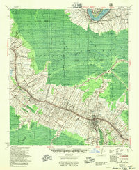
1955 Map of Thibodaux
USGS Topo · Published 1955About this map
The Mississippi River and Bayou Lafourche dictate the cultural geography of this Louisiana landscape, where settlement patterns follow the high ground of the natural levees. Large landholdings like Laurel Valley Plantation and Orange Grove Plantation are prominent, accompanied by an extensive network of drainage canals and pumping stations required for sugar cane cultivation. In the mid-1950s, the region was heavily partitioned by parish boundaries between Assumption, St. James, and Lafourche, with many rural communities organized around parish churches and schools.
Find a feature on this map
113 named features on this map. Tap any name to fly to it.
Don’t see what you’re looking for? This feature index may not catch every label — zoom into the map to look around manually.
Map Details
Editions of this 1955 Thibodaux Map
This is the sole edition of this map. No revisions or reprints were ever made.
Other maps of this area

1892 · Lac Des Allemands
USGS Topo · 1:62,500

1892 · Mount Airy
USGS Topo · 1:62,500

1892 · Gibson
USGS Topo · 1:62,500

1892 · Houma
USGS Topo · 1:62,500

1892 · Donaldsonville
USGS Topo · 1:62,500

1892 · Thibodaux
USGS Topo · 1:62,500

1897 · Gibson
USGS Topo · 1:62,500

1927 · Thibodaux NW
USGS Topo · 1:31,680

1932 · Lac Des Allemands NW
USGS Topo · 1:31,680

1932 · Lac Des Allemands SW
USGS Topo · 1:31,680