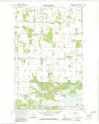
1967 Map of Thief Lake NW
USGS Topo · Published 1984About this map
The Nereson State Wildlife Management Area anchors the southern portion of this landscape, illustrating the extensive conservation and land management practices established in Roseau County by the late 1960s. The region is characterized by township-level organizational units like Stokes, Nereson, and Poplar Grove, which reflect the low-density, rural settlement patterns typical of this northern borderland. Local community life is represented by specific spiritual and memorial landmarks, including the Nannestad Ch and Faith Ch, alongside a small Cem in the northern sections. The map reveals a transition between organized agricultural townships and the more open, marshy terrain of the state-managed wildlife area, providing a clear look at how early 20th-century settlement gave way to broader environmental preservation in the region's more difficult-to-farm wetlands.
Find a feature on this map
15 named features on this map. Tap any name to fly to it.
Don’t see what you’re looking for? This feature index may not catch every label — zoom into the map to look around manually.
Map Details
Editions of this 1967 Thief Lake NW Map
2 editions found
Other maps of this area

1918 · Roseau
USGS Topo · 1:62,500

1918 · Garland
USGS Topo · 1:62,500

1918 · Greenbush
USGS Topo · 1:62,500

1919 · Badger
USGS Topo · 1:62,500

1952 · Thief River Falls
USGS Topo · 1:250,000

1954 · Roseau
USGS Topo · 1:250,000

1956 · Thief River Falls
USGS Topo · 1:250,000

1957 · Roseau
USGS Topo · 1:250,000

1957 · Thief River Falls
USGS Topo · 1:250,000

1958 · Roseau
USGS Topo · 1:250,000